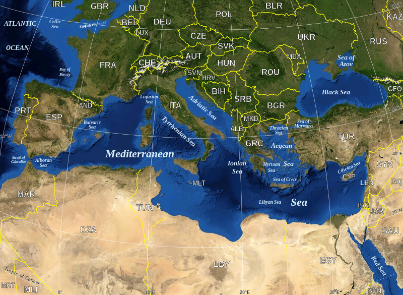
Datoteka:Mediterranean Sea political map-en.svg

Veličina ovog PNG prikaza ove SVG datoteke: 800 × 585 piksela. Ostale razlučivosti: 320 × 234 piksela | 640 × 468 piksela | 1.024 × 749 piksela | 1.280 × 936 piksela | 2.560 × 1.872 piksela | 2.046 × 1.496 piksela.
Vidi sliku u punoj veličini (SVG datoteka, nominalno 2.046 × 1.496 piksela, veličina datoteke: 1,11 MB)
Povijest datoteke
Kliknite na datum/vrijeme kako biste vidjeli datoteku kakva je tada bila.
| Datum/Vrijeme | Minijatura | Dimenzije | Suradnik | Komentar | |
|---|---|---|---|---|---|
| sadašnja | 18:07, 4. ožujka 2020. |  | 2.046 × 1.496 (1,11 MB) | Ifwest | File uploaded using svgtranslate tool (https://tools.wmflabs.org/svgtranslate/). Added translation for fallback. |
| 18:18, 19. svibnja 2008. |  | 2.046 × 1.496 (1,1 MB) | Sting | "Tropic of Cancer" label correction | |
| 03:01, 21. lipnja 2007. |  | 2.046 × 1.496 (1,1 MB) | Sting | {{Information |Description=Map in English of the Mediterranean Sea, with the borders and the name of the States following the ISO 3166-1 Alpha-3 code. |Source=Own work ;<br/>Background map : screenshot from NASA World Wind (Publi |
Uporaba datoteke
Nijedna stranica ne rabi ovu datoteku.
Globalna uporaba datoteke
Sljedeći wikiji rabe ovu datoteku:
- Uporaba na ab.wikipedia.org
- Uporaba na arz.wikipedia.org
- Uporaba na ast.wikipedia.org
- Uporaba na ba.wikipedia.org
- Uporaba na bcl.wikipedia.org
- Uporaba na be-tarask.wikipedia.org
- Uporaba na bn.wikipedia.org
- Uporaba na br.wikipedia.org
- Uporaba na ca.wikipedia.org
- Llista de topònims d'Alcanar
- Llista de topònims d'Amposta
- Llista de topònims de la Ràpita
- Llista de topònims de Sant Jaume d'Enveja
- Llista de topònims d'Altafulla
- Llista de topònims de Creixell
- Llista de topònims de Roda de Berà
- Llista de topònims de Salou
- Llista de topònims de Tarragona
- Llista de topònims de Torredembarra
- Llista de topònims de Vila-seca
- Llista de topònims de Calafell
- Llista de topònims de Cunit
- Llista de topònims del Vendrell
- Llista de topònims de Cubelles
- Llista de topònims de Sitges
- Llista de topònims de Vilanova i la Geltrú
- Llista de topònims de Begur
- Llista de topònims de Calonge i Sant Antoni
- Llista de topònims de Castell d'Aro, Platja d'Aro i s'Agaró
- Llista de topònims de Palamós
- Llista de topònims de Pals
- Llista de topònims de Sant Feliu de Guíxols
- Llista de topònims de Lloret de Mar
- Llista de topònims de Tossa de Mar
- Llista de topònims d'Arenys de Mar
- Llista de topònims de Cabrera de Mar
- Llista de topònims de Caldes d'Estrac
- Llista de topònims de Calella
- Llista de topònims de Canet de Mar
- Llista de topònims de Malgrat de Mar
- Llista de topònims de Mataró
- Llista de topònims de Montgat
- Llista de topònims de Pineda de Mar
- Llista de topònims de Sant Andreu de Llavaneres
- Llista de topònims de Sant Pol de Mar
- Llista de topònims de Sant Vicenç de Montalt
- Llista de topònims de Vilassar de Mar
- Llista de topònims del Prat de Llobregat
Pogledajte globalnu uporabu ove datoteke.


