
Datoteka:John-Tallis-1851-Tibet-Mongolia-and-Manchuria-33621.jpg

Vidi sliku u punoj veličini (4.030 × 3.102 piksela, veličina datoteke: 12,64 MB, MIME tip: image/jpeg)
| Ova je datoteka sa Zajedničkog poslužitelja i mogu je rabiti drugi projekti. Opis s njezine stranice s opisom datoteke prikazan je ispod. |
Sažetak
| Opis |
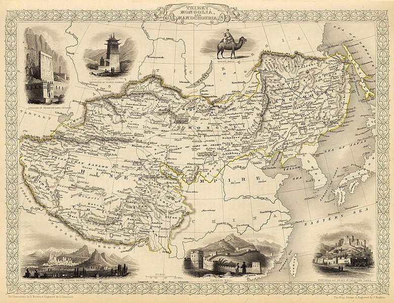
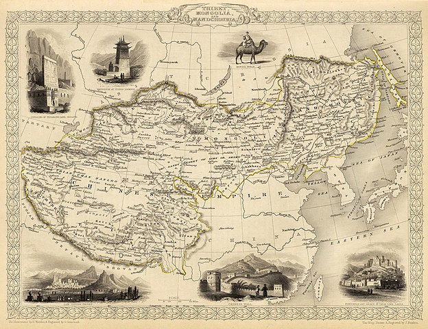
English: Map of the northern and western part of the Chinese Empire - "Thibet, Mongolia, and Mandchouria". The borders are shown as per the 1686 Treaty of Nerchinsk. (They were to be changed drastically in 1858-60, by treaty of Aigun and subsequent agreements). The main Russian center in Transbaikalia is still Nerchinsk, rather than Chita. The outline of Sakhalin Island is already shown fairly correctly, but the body of water separating it from the mainland is still labeled "Gulf of Tartary" (rather than '"Strait).
Français : Carte des parties Nord et Ouest de l'Empire chinois — « Thibet, Mongolie and Mandchourie ». Les frontières sont montrées telles qu'elles étaient définies par le Traité de Nerchinsk de 1686. (Elles allaient être grandement changées en 1858-1860 par le traité d'Aigun et les accords suivants). Le principal centre russe en Transbaïkalie est encore Nerchinsk, plutôt que Chita. Le contour de l'île Sakhaline est déjà décrit très correctement, mais l'étendue d'eau la séparant du continent est encore qualifiée de « golfe de Tartarie » (plutôt que « détroit »).
中文:中国皇国,北部和西部。 |
| Datum | |
| Izvor | John Tallis' atlas of the world. Reproduced at http://www.davidrumsey.com/luna/servlet/detail/RUMSEY~8~1~821~60126:Thibet,-Mongolia,-and-Mandchouria-- (the last version uploaded is from there), http://www.jpmaps.co.uk/mapimages/originals/33621.jpg , and elsewhere |
| Autor | Martin, R.M.; Tallis, J. & F. The staff of John Tallis: The Illustrations by H. Winkles & Engraved by G. Greatbach. The Map Drawn & Engraved by J. Rapkin. |
| Ostale inačice | Radovi izvedeni od ove datoteke: John-Tallis-1851-Tibet-Mongolia-and-Manchuria-NE.jpg |
Licencija
|
Ovo je djelo u javnom vlasništvu u zemlji podrijetla i u drugim zemljama s rokom trajanja autorskih prava za života autora plus 70 godina ili manje.
| |
| Ova datoteka je identificirana kao slobodna od poznatih ograničenja po zakonu o autorskim pravima, uključujući sva povezana i srodna prava. | |
Povijest datoteke
Kliknite na datum/vrijeme kako biste vidjeli datoteku kakva je tada bila.
| Datum/Vrijeme | Minijatura | Dimenzije | Suradnik | Komentar | |
|---|---|---|---|---|---|
| sadašnja | 22:51, 28. veljače 2016. | | 4.030 × 3.102 (12,64 MB) | Centpacrr | Crop |
| 04:26, 7. prosinca 2009. |  | 4.700 × 3.750 (4,07 MB) | Vmenkov | better resolution, as available from http://www.davidrumsey.com/luna/servlet/detail/RUMSEY~8~1~821~60126:Thibet,-Mongolia,-and-Mandchouria-- | |
| 03:38, 7. prosinca 2009. |  | 1.289 × 989 (386 KB) | Vmenkov | {{Information |Description={{en|1=Map of the northern and western part of the Chinese Empire - "Thibet, Mongolia, and Mandchouria". The borders are shows as per the 1858 treaty of Aigun. The main Russian center in Transbaikalia is still Nerchinsk, rather |
Uporaba datoteke
Na ovu sliku vode poveznice sa sljedećih stranica:
Globalna uporaba datoteke
Sljedeći wikiji rabe ovu datoteku:
- Uporaba na ar.wikipedia.org
- Uporaba na en.wikipedia.org
- Uporaba na fr.wikipedia.org
- Uporaba na mn.wikipedia.org
- Uporaba na sh.wikipedia.org
- Uporaba na vi.wikipedia.org